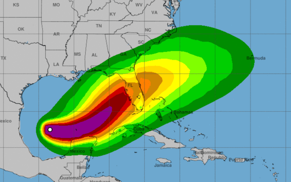
Ten days after the Southeast was wracked by Helene, one the deadliest storms in modern history, the National Weather Service today forecast that newly-formed Hurricane Milton is headed toward central Florida and could impact the entire state.
“Milton is forecast to move just north of the Yucatan Peninsula and across the southern Gulf of Mexico on Monday and Tuesday and approach the west coast of the Florida Peninsula by Wednesday,” reads a NWS report.
“Maximum sustained winds have increased to near 90 mph (150 km/h) with higher gusts. Milton is forecast to intensify rapidly and become a major hurricane on Monday.”
That means Milton will shift from a tropical storm to a Cat. 3 hurricane in the space of 24 hours. Cat. 3 on the Saffir-Simpson Scale means winds of 111-129 mph. Per the NWS, “The official intensity forecast…shows Milton rapidly strengthening to category 4 intensity within the next couple of days.” Thankfully, it is expected to weaken slightly before reaching the west coast of Florida. According to the chart below, it is expected to make landfall as a major hurricane, likely Cat. 3.
Hurricane-force winds currently extend outward up to 25 miles from the center and tropical-storm-force winds up to 80 miles out.
Florida Governor Ron DeSantis said Sunday that most of the state will likely be impacted. He has declared a state of emergency in 51 counties, including Hillsborough, Pinellas, Pasco, Miami-Dade and Broward.
“I don’t think there’s any scenario where we don’t have significant impacts at this point,” he said at a news conference. “If you’re on that west coast of Florida and barrier islands, just assume that you likely are going to be called upon to evacuate.”
Unnamed hurricanes of 1909, 1910, 1929, 1933, 1945, and 1949 were all Category 3 storms when they struck South Florida, as were King of 1950, Betsy of 1965, Jeanne of 2004, and Irma of 2017. Milton would be the third hurricane to hit the state this year.
The current forecast cone, which could change drastically in the next two days, has Milton making landfall just south of Tampa Bay which just 10 days ago saw a storm surge of eight feet on some of the barrier islands in and around Pinellas County. Local officials there are desperately trying to clean up debris from Helene so they don’t become airborne or floodborne projectiles.
Officials told the Tampa Bay Times that Milton could be far worse than Helene. Sewage systems and power could be out for weeks, according to the paper’s reporting.
DeSantis warned in a statement posted to social media that the storm threatens more than just the state’s west coast.
“Impacts will be felt across the Florida peninsula, as Milton is forecasted to exit Florida’s east coast as a hurricane,” wrote the governor.
In a news conference with the governor, Florida Division of Emergency Management Director Kevin Guthrie told residents, “I highly encourage you to evacuate. We are preparing, and I have the State Emergency Response Team preparing, for the largest evacuation that we have seen most likely since 2017 Hurricane Irma.”
The storm’s current projected path takes it over Orlando, with the region and its theme parks just on the edge of the greatest projected risk of flash flooding over the next five days, at 40%. During Helene, Walt Disney World and Universal Orlando mostly stayed open, closing only a few outdoor attractions.
Peppa Pig Theme Park Florida closed its doors on September 27, after the storm damaged attractions at the preschool experience. SeaWorld Orlando shut at 2 p.m on the 26th. Busch Gardens Tampa, Adventure Island, and Aquatica Orlando also shut down that day.
Orange and Osceola Counties, in which the parks sit, are among those DeSantis placed under a state of emergency this weekend in anticipation of the storm. Currently, both of the Orlando parks have issued notices that they are currently operating as normal but “closely monitoring” the storm as it develops.
Of note, the low-lying area in and around Miami is also projected to be at the greatest flash flood risk.


Per the NWS, “After crossing Florida, the cyclone should turn east-northeastward to eastward over the Atlantic waters off the southeastern United States.” Currently, it looks set to spare hard-hit western North Carolina.


